Capturing Scotland’s Heritage in 3D: the Fascinating Skills of Digital Documentation
Digital, Heritage, Science, Skills | Written by: Yueqian Wang | Wednesday 22 May 2024
Yueqian Wang is our Digital Innovation Trainee based at the Engine Shed, Stirling. Working across Scotland and using examples from several Properties in Care, Yueqian shares four key concepts used to digitally capture our heritage.
Historic Environment Scotland’s (HES) Digital Documentation and Innovation team document the historic environment in three dimensions (3D) using cutting-edge technologies, and apply this data in innovative ways for conservation, accessibility, learning and engagement.
At HES, we capture all kinds of heritage, from small items to whole sites, using a variety of methods and digital skills. In this blog, I will explain several methods of digital documentation, including 3D laser scanning, control survey, photogrammetry and 360 photography.
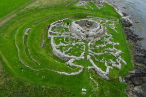
Aerial view of the Broch of Gurness, Orkney. The Broch is the circular structure near the centre of the site, surrounded by settlement structures.
Fieldwork
First though, the most important step in our process is where we travel to and work on-site to accurately capture it in full. Fieldwork is a great opportunity for me to learn the methods of capture while troubleshooting the unique challenges each site offers.
As a team, we aim to document all HES Properties in Care across Scotland. Some of our most beautiful sites are located on the remotest islands, which are not the easiest places to travel to. To reduce our carbon footprint at work, our journey is usually a mixture of carpooling and ferries.
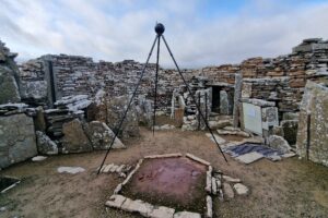
Scheduling everything into a week on the islands can be quite challenging, but the beauty of these heritage sites is always rewarding after long travels. Last summer, we worked across four locations in Orkney, including the Broch of Gurness, and I tried my hand at many key techniques and methods.
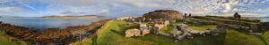
A panoramic photo taken at the Broch of Gurness, Orkney.
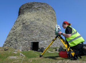
3D laser scanning
We use 3D laser scanners to capture the measurements and geometry of sites. A laser scanner works by sending out invisible laser beams in different directions that then bounce back after hitting a surface. The laser scanner will measure the time it takes, in order to calculate the position of that point in 3D space.
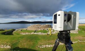
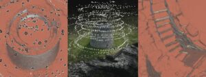
Scanning the Broch of Gurness, Orkney.
The way laser scanners see the environment affects the way we work. Since the laser beam cannot penetrate most materials, we need to scan from different positions to get full coverage of the site. The key is to strike the right balance: the scans should have some overlapping between them to align together, but not too many scans over the same area which can cause issues. We use a Leica RTC360 3D Laser Scanner, which can document millions of points in one scan and it is crucial to avoid repeat scans to keep the file size manageable.
The Broch of Gurness was a challenge to strike that balance. There were many areas to scan and the small stone structures were not tall enough to block lasers from repetitively scanning the Broch in the centre of the site. To combat this, we lowered the resolution of the scan as well as the height of the scanner. This avoided too much overlap of the main broch while capturing the many details of the site.
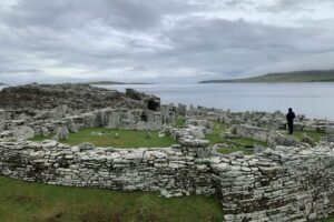
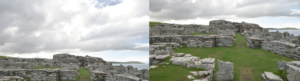
The low walls at the Broch of Gurness are a challenge for data capturing.
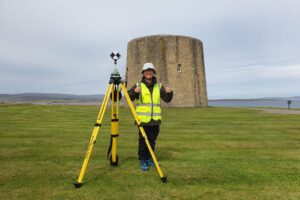
Control survey
When tailoring the documentation method to different sites, our fieldwork can be agile but there are always aspects that stay the same. We can think of a project like a human body: bones, muscle and skin.
The control survey acts as the bone pinning down the precise location of the site and acting as the foundation for accuracy. The laser scanning data is the muscle recording detailed geometry built on that control. Finally, images taken are the skin, giving the photo-realistic detail we see in the final product.
Digital Documentation Officer Laura O’Connor doing control survey at Mousa Broch, Shetland.
Carrying out a control survey can put the 3D data into context. It can be used to see its accurate position on Earth or make comparisons between records of the same sites over the years.
This is done by surveying the positions of Permanent Survey Markers. They are carefully placed on the site, usually dotted around the boundary where they are less intrusive. A typical Permanent Survey Marker we use is a survey nail placed on a solid concrete block.
Most of the time, the markers are buried under the turf, which protects the survey nail from weathering. During the survey, we uncover the turf and note their location, which is placed on a global map in a process called geo-referencing.
Keeping a precise control survey is important for data analysis, especially for sites being monitored over time. The monitoring project of Skara Brae under climate change, for example, relies on the robust control survey data.
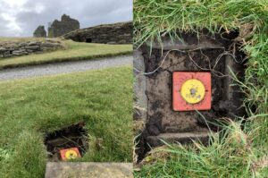
Example of a Permanent Survey Marker (with the turf having been removed) at Jarlshof Prehistoric and Norse Settlement, Shetland.
Capturing data with targets
Another challenge comes with cylindrical objects, especially ones without many distinctive features, such as Hackness Martello Tower and Battery. To get reliable alignment with our scanners at the tower, black and white targets were set across the site with each scan capturing at least three common targets. Later in the office, the centre of the black and white target is identified by data processing software as known features, making it easier to match different scans together.
Generally, the more common targets, the more robust the link will be. Our top tip is to set the targets far away from each other and with varied positions and heights.
Yueqian Wang standing beside a black and white target at Hackness Martello Tower and Battery, Orkney.
Photogrammetry
Photogrammetry is a method using multiple 2D photographs to create a 3D dataset. The processing software detects the same points in the photos, then calculates their position in the 3D space.
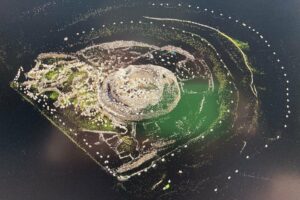
Screenshot of processing the photogrammetry data at Broch of Gurness, Orkney.
Unlike laser scan survey that requires a specific instrument, the processing workflow of photogrammetry works for most images. These can be photographs taken by anything from mobile phones to drone cameras.
Drone photogrammetry allows us to gather data with greater mobility. For example, a drone can capture tops of buildings that a scanner cannot see. Drones are also flexible in unreachable spaces that are risky for laser scanning, making it a good way to fill in the gap of inaccessible areas.
Composite screenshots of processing drone photogrammetry at Mousa Broch, Shetland. The dark/white boxes show the drone camera positions. The final image is a closeup of the top of the broch walls.
Using high-resolution images for photogrammetry can improve the quality of 3D assets. A common approach is to take photos with a DSLR camera from ground level. Here are some handy starter tips I have learned:
- move around the object! For photogrammetry, what you capture in the frame is what you get in a 3D model. You need to move around the object or building to get full coverage
- use every pixel. It is good to fill your frame with the object you want to capture, and in this example at the Broch of Gurness, it is a stone structure, not the sky
- have plenty of overlap from photo to photo. Similar with laser scans, overlapping helps the photos to align. 60% overlap between one photo to another gives ideal coverage.
Composite image showing poor composition (left) and good composition (right) of the Broch of Gurness.
360 photography
Our work is not limited to documenting sites with a scanner. We also work to improve accessibility and people’s experience of our heritage, especially for remote sites.
We have been using 360 photography to capture sites to enhance their experience in different ways, such as in Virtual Reality and on immersive screens. Using two or more lenses to take photos at the same time, 360 cameras record their surroundings in just one photo, from the ground to the top of the ceiling.
Taking 360 photos at the centre of the Broch of Gurness, Orkney
These digital skills are just some of the ways in which we document the historic environment. Working as a HES trainee is great for learning practical knowledge and problem-solving skills in digital heritage.
In the active part of fieldwork, I get to learn unique ways of digitally capturing sites, and I will be sharing more learning and top-tips in digital documentation over the course of my traineeship. If you are interested in more detailed technical knowledge, please stay tuned as there will be a new blog discussing photogrammetry skills used in projects.
A 360 photo taken at Hackness Martello Tower and Battery, Orkney.
Find out more
Yueqian is our Digital Innovation Trainee as part of our Trainee and Craft Fellowship Programme. We advertise all Craft Fellowship, Trainee and Apprenticeship vacancies on the Historic Environment Scotland website when available.
Interested in digital documentation or topics related to built heritage and conservation? Considering a career in building conservation or want to develop your skills? Find out more about building conservation training and skills development and explore our learning opportunities at the Engine Shed.
Find out more about our Digital Documentation and Innovation team. Explore our models made through 3D scans available on Sketchfab.
Learn about digital skills and techniques for heritage, with our blogs.
Our free building advice has our latest research and best practice on traditional building materials, components, common defects, and energy efficiency.
- Share this:
- Share this page on Facebook
- Share on X
About the author:
Yueqian Wang
Yueqian Wang is a Digital Innovation Trainee at the Engine Shed, working jointly with Historic Environment Scotland's Digital Documentation and Innovation team and the National Trust for Scotland. She graduated in Architectural Conservation from the University of Edinburgh. Her traineeship explores the ways digital documentation can be innovatively applied to the heritage sector as a tool for site management, accessibility, monitoring, and more.
View all posts by Yueqian Wang
